100% All-Natural Composition
No Artificial Intelligence!
Showing posts with label satellites. Show all posts

Tuesday, February 26, 2013

The strange Cold War bar codes across America

Mysterious bar code on the ground, United States, Cold War, surveillance aircraft, spy satellites
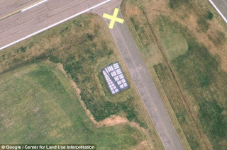
The "bar code" at Walker Field, Maryland
Adjacent to the runway of a Navy airfield in Maryland is a paved rectangle.  And within that area are a series of quadrilaterals painted bright white, in pairs and ascending in size.

By itself its existence would be a mystery, or at least a curiosity.  Except that it is one of dozens to be known throughout the United States, with most of those found near military bases and other restricted facilities.  Some remote locations have entire arrays of the "bar codes" stretching for miles toward the horizon.

So what are these test pattern-ish arrangements?  Based on available evidence, they seem to have been put in place by the government during the first few decades of the Cold War.  With tensions high between the U.S. and the Soviet Union, the advent of high-altitude aircraft reconnaissance - and then "spy" satellites - became an important asset of military intelligence.  And as with any other system of optics those high-flying cameras needed a means of determining that they were properly focused.

The rectanglular codes, therefore, are apparently intended to calibrate the zoom and resolution of aircraft and satellite photography.  F'rinstance: letting an SR-71 use one to adjust its precision camera before sending it to fly across the Iron Curtain.

From the original article at Mail Online...
Consisting of a concrete pad measuring 78ft by 53ft and coated in a heavy black and white paint, they are decorated with patterns consisting of parallel and perpendicular bars in 15 or so different sizes.
This pattern, sometimes referred to as a 5:1 aspect Tri-bar Array, is similar to those used to determine the zoom resolution of microscopes, telescopes, cameras, and scanners.
The targets function like an optician's eye chart, with the smallest group of bars discernable marking the limit of the resolution for the camera being tested, according to the CLUI.
'For aerial photography, it provides a platform to test, calibrate, and focus aerial cameras traveling at different speeds and altitudes,' the CLUI adds.
'The targets can also be used in the same way by satellites.'
Ironic, aye?  That military secrets from fifty years ago are now wide-out in the open because of that same technology and Google Earth.  Anyone with a desktop or tablet can now view what likely had been classified top secret by the CIA.

I wonder what else might be on the ground across the fruited plain, waiting to be discovered...

Tuesday, May 19, 2009

GPS system could start dying next year

The Global Positioning System may be months away from beginning to fail, it has been been announced. Mismanagement and a failure to maintain the fleet of satellites at the heart of the system now threatens to put both military and civilian use of GPS in tremendous jeopardy starting sometime in 2010.

Here's hoping that this can be remedied and soon. I just recently started using GPS for highway navigation (a unit from TomTom) and it has already become an essential part of my business ventures. But then you get to considering the reason why GPS was first made available for public use to begin with, and you come to realize the urgent gravity of the situation.

(Thankfully, Soviet-controlled airspace at least has been defunct for the past 18 years. But absent modern navigation that much of the world has come to depend on, and it's not hard to imagine a similar incident happening in any number of places.)

Wednesday, February 11, 2009

Two satellites collide in space over Siberia

At least 600 pieces of spaceborne shrapnel are now plaguing the sky, no thanks to an unprecedented collision between two satellites in low-Earth orbit.

Early yesterday, 790 kilometers (490 miles) above Siberia, an inoperative Russian satellite called Cosmos 2251 smashed into Iridium33, a communications satellite. Ground radar is now tracking the hundreds of resulting bits of debris, hoping that none of it will smash into any other satellites or the International Space Station.

When asked which satellite was at fault, NASA scientist Nicholas Johnson said, "they ran into each other. Nothing has the right of way up there. We don't have an air traffic controller in space. There is no universal way of knowing what's coming in your direction."

The good news, if there is any, is that Iridium Satellite LLC still has 64 satellites in unusually low orbit, relaying calls between special satellite phones (the U.S. Department of Defense is one of its biggest customers).

I wonder if one of them was trying to speed through an intersection...